
Updated every 3 minutes, daily changeover occurs at 9am
Weather conditions at 06:54:50 local time on 23 July
Current local time:
|
Bureau of Meteorology Forecast: Forecast for the rest of Thursday 23 July Mostly sunny. Light winds becoming westerly 15 to 25 km/h in the middle of the day then tending southwesterly 15 to 20 km/h in the late afternoon. City Centre Mostly sunny. Max 20 Chance of any rain: 10% Penrith Mostly sunny. Max 21 Chance of any rain: 10% Around Sydney Bondi Max 19 Parramatta Max 20 Campbelltown Max 19 Richmond Max 21 Liverpool Max 20 Terrey Hills Max 19 |
|
Reproduced with the permission of the Bureau of Meteorology |
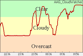
06:54:50 :- Sky above the weather station is now Clear and +9.3 °C and Rising
| Current Sutherland Shire Weather Snapshot - updated every 3 minutes | |||
| Outside Temperature | +9.3 °C and Rising | Barometric Pressure | 1012 hPa and Steady |
| Outside Humidity | 78 % and Rising | Dew Point | +5.7 °C and Rising |
| Wind Speed (gust) | 7.2 km/h (3.9 knots) from 258° (W) | Last Rainfall Rate | 0 mm/hour, 0 mm since 9am 0 mm Yesterday |
| Wind Speed (av.last 10 min) | 3.6 km/h (2 knots) | 24-48 Hour Future Forecast | |
| Wind Direction (Gust) | 258° (W) | (according to weather station) | |
| Wind Direction (av.last 10 min) | 258° (W) | ||
| Live Cloud Sensor - updated every 3 minutes, sky directly overhead is now Clear | ||
| 4 hr Cloud Trend |
|
 |

|

|
|
|
|||||||
|
Select from the following categories to view more detailed weather information, or scroll down. |
|||||||
| Outside Temperature |
Outside Humidity |
Barometric Pressure |
Wind | Rainfall | Solar/Lunar | Historical Data |
So Far This Month |
UV Index Map | Moon Phase Chart |
Sunrise/Set, Moonrise/Set Times |
Local 7 day Sydney Forecast | Local Radar Rain Wind |
Australia Windmap | Synoptic Outlook |
Distance Between Two Points |
| Outside Temperature | ||
| Current Temperature | +9.3 °C and Rising |
|
| Today's Minimum | +8.3 °C at 06:01 | |
| Maximum | +20.6 °C at 13:47 | |
| Yesterday's Minimum | +8.8 °C at 06:08 | |
| Maximum | +20.8 °C at 14:41 | |
| Year-to-Date Minimum | +5.4 °C at 05:41 on 14 July | |
| Maximum | +44.8 °C at 16:49 on 10 January | |
| Current Wet Bulb Temperature | +7.6 °C | |
| Current Wet Bulb Depression | +1.7 °C | |
| Current Dew Point | +5.7 °C | |
| Today's Minimum | -1.8 °C at 13:30 | |
| Maximum | +10.2 °C at 09:00 | |
| Yesterday's Minimum | +4 °C | |
| Maximum | +12.2 °C | |
| Current Wind Chill | +9.3 °C | |
| Current Heat Index | n.a. | |
| Outside Humidity | |||
| Current Humidity | 78 % and Rising | ||
| Today's Minimum | 23 % at 13:49 | ||
| Maximum | 87 % at 09:01 | ||
| Yesterday's Minimum | 34 % at 14:55 | ||
| Maximum | 90 % at 08:30 | ||
| Year-to-Date Minimum | 10 % at 13:58 on 05 February | ||
| Maximum | 94 % at 04:41 on 27 February | ||
| Barometric Pressure | ||
| Current Barometric Pressure | 1012 hPa and Steady | |
| Today's Minimum | 1012 hPa at 06:54 | |
| Maximum | 1015 hPa at 10:57 | |
| Yesterday's Minimum | 1015 hPa at 08:59 | |
| Maximum | 1022 hPa at 10:12 | |
| Est. Cu Cloud Base Height | 450 meters. (1476 feet) | |
| Wind | |||
| Latest Wind Gust | 9.4 km/h | Gust Direction | 258° (W) |
| 10-minute Wind Average | 3.6 km/h | Average Direction | 258° (W) |
| Today's Maximum Gust | 16.2 km/h, 234° at 19:52 | Today's Wind Run | 72.198 Kilometers |
| Yesterday's Maximum Gust | 14.8 km/h, 44° at 11:31 | Yesterday's Wind Run | 29.91 Kilometers |
| Year-to-Date Maximum |
37.4 km/h, 156° at 16:30 on 02 February |
||
|
|
|
||
| Rainfall | ||
| Current Rainfall Rate | ||
| Today's Total Rainfall Since 9am | 0 mm | |
| Today's Maximum Rate | nil | |
| Yesterday's Total Rainfall | 0 mm | |
| Yesterday's Maximum Rate | nil | |
| Days Since Last Measured Rain | 5 | |
| Last Measured Rain | 24 mm | |
| Year-to-Date Total Rainfall | 499 mm of rain since 09:00 on 01 January | |
| Solar / Lunar | |||||||||||||
| Yesterday | Today | Tomorrow | |||||||||||
| Sun Rise | 06:55:32 | 06:54:59 | |||||||||||
| Sun Set | 17:09:14 | 17:09:53 | |||||||||||
| Moon Rise | 11:15 | 11:47 | 12:23 | ||||||||||
| Moon Set |
00:28 |
01:29 |
02:28 |
||||||||||
|
|
|||||||||||||
| Current Moon Phase | Waxing Gibbous | ||||||||||||
|
Percent Illuminated |
61.4% | ||||||||||||
|
Next New Moon |
13 August 2026 03:37 |
||||||||||||
|
Next First Quarter |
20 August 2026 12:47 |
||||||||||||
|
Next Full Moon |
30 July 2026 00:36 |
||||||||||||
|
Next Last Quarter |
06 August 2026 12:22 |
||||||||||||
|
Start Civil Twilight |
started at 06:28:37 |
||||||||||||
|
End Civil Twilight |
will end at 17:36:11 |
||||||||||||
|
Length of Day |
10 h 13 m |
||||||||||||
|
Length of Visible Light |
11 h 7 m |
||||||||||||
Email the Weather Station
Thanks for visiting Visitors since 1 January 2003 How this all worksSmall Print: Weather station is privately owned, operated and funded, and provided as a free public service. Weather data is not quality controlled and continuity of service is not guaranteed. So there ! This page is best viewed at a resolution above 1024x768. We use the Oregon Scientific WM918 Weather Station
| |||||||||||||